
ATCOR® - Example Processing Results
Overview | Examples | Alternatives | Documentation | ATCOR-2/3 | ATCOR-4
For satellite sensors with a small field-of-view (FOV) the solar and view geometry can be treated as approximately constant. Since satellite sensors operate outside the earth's atmosphere a database of atmospheric correction functions can be compiled for a common altitude based on calculations with a radiative transfer code. This database was compiled for the satellite sensors supported by ATCOR 2/3. However, airborne sensors operate in a range of tropospheric altitudes and typically have a large field-of-view. Therefore, a compilation of the corresponding airborne atmospheric database has to account for the altitude dependence and the scan angle dependence.
Therefore, the ATCOR models have been split into separate codes optimized for satellite sensors and airborne sensors; some sample results are given hereafter.
ATCOR for Satellite Imagery
Models ATCOR 2 (flat terrain) & ATCOR 3 (rugged terrain) - for small FOV sensors
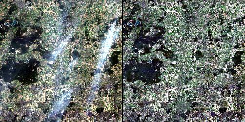
Examples: The following image shows part of a Landsat-5 TM scene in a flat terrain recorded on 20 August 1989. The left image shows the original scene, the right image is the processed surface reflectance scene employing ATCOR's haze removal algorithm in the hazy regions.
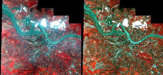
Another example shows part of an Ikonos scene of Dresden, 18 August 2002, ©Space Imaging Europe 2002, demonstrating a successful haze removal. Ikonos bands 4, 2, 1 (NIR, Green, Blue) are color coded RGB.
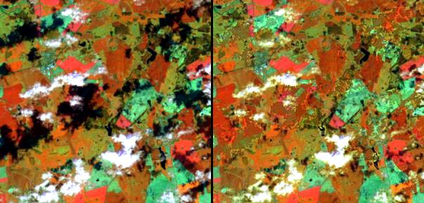
The next image is a small Landsat-5 TM sub-scene of Makhtesh-Ramon (Israel) acquired on 21st September 1995. The image was processed in the framework of a joint German-Israeli Foundation project. The top part presents the original data of TM bands 7/4/1 (coded RGB), the bottom part is surface reflectance after combined atmospheric/topographic correction. Most of the topographic features that can be seen in the original image are eliminated in the surface reflectance image.

Starting in 2005, the ATCOR versions include an algorithm for the removal of cloud shadow effects. An example of a Landsat-7 ETM+ sub-scene is shown below. The scene was recorded on May 1st 2000, and covers part of a rural area from Mecklenburg, Germany. The solar zenith angle was 41 degree, the RGB is displayed with ETM bands 4/5/3 (830/16050/660 nm).
ATCOR for Airborne Imagery
Model ATCOR 4 - flat and rugged terrain for wide FOV sensors
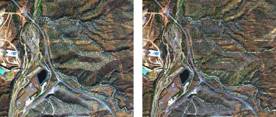
Example: The image shows a low altitude AVIRIS scene acquired on 3rd October 1998 (channel 35 at 682 nm). The image was first ortho-rectified (with PARGE) to a USGS digital elevation model resampled from the original 30 m resolution to the 3.6 m AVIRIS resolution. The elevation of the scene ranges between 500 and 800 m. The lower part of the mosaicked image shows the result after combined atmospheric & topographic correction. The residual topographic structures are mainly caused by the 30 m DEM resolution which is not able to follow rapid terrain changes in the 3.6 m pixel scale of AVIRIS.
An example of de-shadowing of an airborne scene is presented next. In this case, the clouds are located outside of the acquired scene, yet the cloud shadow removal works fine. The scene was recorded by the HyMap sensor on July 12th, 2003, near Chinchon, Spain. The solar zenith and azimuth angles were 18.3 degrees and 124.8 degrees, respectively. The color coding is RGB = 878/646/462 nm.
