
PARGE® Results
PARGE: Overview | Background | Features | Method | Results | Screenshots | Trafo Viewer
Since the first release of PARGE in the year 2000, a vast amount of data from AVIRIS, DAIS 7915, Hymap, CASI, MIVIS, and more recently from the Probe-1, AHS, AISA Eagle, PHILLS, and SAMSON instruments has been successfully processed. The processing is done in both, research environments using the PARGE workbench structure and in operational large volume processing using the batch processing capabilities of the software. The output accuracies are directly related the input parameter quality, while the various calibration procedures within PARGE help to improve quality and reliability of the outputs. With recent data sets, sub-pixel accuracies below 0.2 pixels could be proven in relation to orthophoto data basis, using high accuracy and well integrated IMU systems. An example of Florida Environmental Research Institute's Spectroscopic Aerial Mapping System with Onboard Navigation (SAMSON) sensor shows the good agreement on the basis of 1m spatial resolution:

Overlay of two mosaiked SAMSON flight lines with an aerial Orthophoto in an
urban environment.
© FERI/ReSe 2007
The quality assessment in comparison to official topographic maps shows pixel-accurate agreement, e.g. for HYMAP imagery, flown in 2004 in Switzerland:

Orthorectified HYMAP imagery, overlaid with rasterized topographic map
© RSL/ReSe 2004
Such orthorectification is well suited for combination of terrain altitude information with the thematic analysis results. An overlay of mosaicked HYMAP imager on a terrain model is shown below:

Orthorectified and mosaicked HYMAP imagery on DEM © RSL/ReSe 2004
Visible offsets in the images may occur whenever the Digital Elevation Model does not represent the surface elevation exactly as over forests or settlements, as shown in the below example, processed on a non-optimal terrain model:
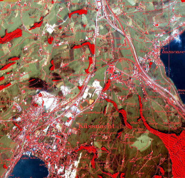
Geocoded DAIS 1997 over Kuessnacht (Switzerland), in comparison with
a digital topographic map
© Daniel Schläpfer, Remote Sensing Laboratories, 1997
As input data quality has improved, the development focus now is on full automatization. Another effort has to be done on quality assessment to allow calculation of the accuracy values for each geocoded image.