
The ATCOR 2/3 Method
Basics | Features | Sensor Support | Methods | ATCOR-2 Results | ATCOR-3 Results
Processing of bands in the solar region (400 - 2500 nm)
The total signal at a remote sensing sensor consists of four components: path radiance, reflected radiation from the viewed pixel, scattered radiation from the neighborhood, and terrain radiation reflected to the pixel (see Figure 1). The atmospheric conditions (water vapor content, aerosol type, visibility) for a scene can be calculated beforehand from the imagery, provided the spectral range and resolution allows for the parameter retrieval. Alternatively, these values are to be estimated from meteorological data or by analyzing preview reflectances in ATCOR. Then, the surface reflectance spectrum of a target in the scene can be viewed as a function of the selected atmospheric parameters. It can be compared to typical library spectra.
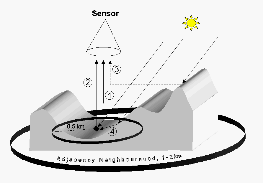
Figure 1 : Schematic sketch of radiation components for a rugged terrain.
Component 1 : path radiance: radiation scattered by the atmosphere
(photons without ground contact).
Component 2 : reflected radiation from the viewed pixel.
Component 3 : adjacency radiation: ground reflected from the neighborhood
and scattered into the view direction.
Component 4 : terrain radiation reflected to the pixel (from opposite hills,
according to the terrain view factor).
Only component 2 contains information from the viewed pixel.
The reflectance calculation is performed iteratively in 5 or 6 major steps:
- Step 1: the influence of the neighborhood is neglected. A start value for the ground reflectance of the surrounding topography is employed whilst the path radiance component is subtracted from the signal. Shadow cast from surrounding topography is included (result of SHADOW program).
- Step 2: calculation of a low pass filtered reflectance image of step 1. The filter size can be specified by the user (typically 1-2 km, corresponding to a range of R = 0.5 - 1 km for the adjacency effect).
- Step 3: The results of the SKYVIEW program are employed to calculate the contribution of the reflected terrain radiation (component 4) averaging over a box of size 0.5 km. The terrain view factore equals (1 - skyview factor). This step is iterated three times to cause convergence.
- Step 4: Adjacency effect: the atmospheric scattering of radiation between adjacent fields of different reflectances is taken into account (see flat terrain).
- Step 5: Spherical albedo effect: the global flux on the ground depends on the large-scale (1 km) average reflectance. The global flux in the atmospheric LUT's is calculated for a fixed reflectance=0.15 . This iteration performs the update for the spatially varying average reflectance map of the current scene, if the adjacency range R > 0 .
- Step 6: (optional) empirical BRDF correction in areas of steep slopes or low illumination.
Note: if the adjacency range R is selected as R=0 then steps 2 to 5 are omitted. For flat terrain processing (ATCOR-2), step 3 and step 6 are not relevant.
Processing of bands in the thermal region (8 - 13 um)
This section applies to Landsat-4/5 Thematic Mapper band 6, Landsat-7 ETM+ band 6,
ASTER, and possible future thermal band sensors.
Figure 2 shows the radiation components in the thermal region. These are: path
radiance emitted by the atmosphere between ground and sensor, emitted ground
radiance (surface with temperature T and emissivity e), and reflected downwelling
thermal atmospheric flux. The influence of the adjacency effect, i.e. scattered
radiation from the neighborhood, can usually be neglected in the thermal spectral
region, since the scattering efficiency of the atmosphere decreases strongly
with wavelength.
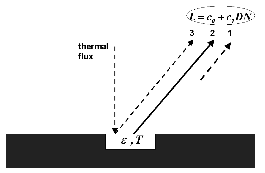
Figure 2 : Schematic sketch of thermal radiation components for a flat terrain.
Component 1 : path radiance: radiation emitted by the atmosphere.
Component 2 : emitted surface radiation from the viewed pixel (emissivity e, temperature T).
Component 3 : reflected downwelling thermal atmospheric flux F, the reflected component is L3=r*F/pi, where r=1-e is the reflectance of the (opaque) surface.
Component 2 contains the essential information from the viewed pixel.
For a sensor with n thermal channels there are n equations with n+1 unknowns,
namely the n surface emissivities plus a surface temperature. So, the system
of equations is always underdetermined. Several possibilities exist to address
this problem. In the ATCOR model, the user can select a constant surface emissivity,
e.g. 0.98 (TM band 6: 10.5-12.5 um, ASTER band 13: 10.3-11.0 um)
for a scene or a surface cover dependent value.
- In case of a cover-dependent emissivity value
a surface (brightness) temperature image is calculated based on an
emissivity estimate for each pixel derived from the reflective bands
of the sensor. Three emissivity classes are currently being used:
- soil/asphalt/sand/mixed pixels (emissivity = 0.96)
- vegetation (emissivity = 0.97)
- water and unclassified pixels (emissivity = 0.98)
The criterion for vegetation is a ratio vegetation index NIR/RED > 2, the criterion for soil is a reflectance > 10% in the RED band. - The emissivity classification is available as a separate file with the extension "*_emi3.bsq". The values are coded as byte data with a scale factor of 100, so the data value 97 corresponds to an emissivity value of 0.97 .
- The temperature channel is appended as the last band. Results are in degree Celsius multiplied by the user-defined scale factor (default=4). In case of possible negative Celsius temperatures the user can specify an offset to stay within the byte data range (0-255) or use a scale factor of 10 in which case the results (reflectance and temperature) will be stored as signed integer (16 bit data range).
After the emissivity selection the surface radiance can be calculated for the chosen atmospheric conditions (water vapor, aerosol content), which is converted to a surface temperature using a 2nd order polynomial approximation of the radiance-temperature relationship. For multi-band thermal data the normalized emissivity method (NEM), adjusted NEM, and in-scene atmospheric correction (ISAC) can also be selected.
Accuracy of the Method
The accuracy of the method depends on several factors :
- radiometric calibration accuracy of the sensor (typically 3-10%)
- radiative transfer code : accuracy of Modtran® 4 by better than 5 % in the atmospheric window regions
- correct choice of atmospheric input parameters : user responsibility
- For near nadir view angles (off-nadir angle < 10 degree), a flat terrain,
and avoiding the specular
and backscattering regions, an accuracy of the retrieval of surface reflectance
of +/-0.02 (reflectance < 0.10) and +/-0.04 (reflectance > 0.40) is possible.
For larger off-nadir view angles bidirectional effects can play a strong role. - The quality of the DEM and the ortho-rectification have a very large influence on the radiometric processing with ATCOR-3 (rugged terrain) (see Reference Publications Richter 1998).
In the thermal region, the surface temperature retrieval additionally depends on the appropriate surface emissivity map. If the deviation of the true surface emissivity from the assumed emissivity is less than 0.02, then the temperatures will be accurate to about 1-1.5 K. Larger deviations will occur if the emissivity estimate is not close to reality. As a rule of thumb, a surface temperature error of about 0.5-0.7 K per 0.01 emissivity error for surface temperatures is much higher than the boundary layer air temperature.